Tuesday, August 31, 2021

31 August, 2021. Ridding the current down big muddy

75 SM; 7.5 hours

 Rain stopped, temperatures dropped and there was a breeze.  Great sleeping last night tied up to the rusty barges at Hoppies.  Bouncy at times as the tows passed but not too bad.  Only real weather issue this morning was potential fog.  But after sunrise, the hills smoked with a wisp of fog; the river appeared clear.  Verified weather, river levels, then completing our boat checklists, we untied the lines and with a bit of throttle eased forward into a nearly three mph current.  Underway at 0700 we turned down river once clear of the barges and started the day.  Overcast from the outer bands of IDA, temperatures remained cool for half of the day.  Mid-day skies began to clear then mostly partly cloudy as the sun warmed up Serenity.  A 10 mph north breeze behind us most of the afternoon and the tropical depression continued moving NE.  Slight chance of thunderstorms this afternoon but further south we traveled, those chances decreased.  

Average over 10 mph speed over ground.  Zooming along.  No delays during the entire day.  

Bluffs along the Mississippi-Missouri side

Impressive tow/barge complexes today.  One was pushing 5x6= 30 barges.  We stayed clear all day.  Current consistent 3+ mph all day.

Huge tow/barge

Buoy and downstream water flow

We have pulled off the river along the Right Descending Bank (RDB) at mile 84.4.  We anchored well outside of the channel in 8 feet of water at 1430.  (Map) Boat perfectly aligned into the current and anchor set very well in sand.  Called a passing tow and were told we were in a safe place for the night.  So here we are.  Kim’s anchor video. 84 miles remaining of the Mississippi River to the Ohio junction.  Will not do it all tomorrow even with the current.

6145 SM journeyed; 2058.4 hours hobbs

30 August, 2021. St. Louis MO extremely congested with massive barges, tows and water traffic


43 SM; 5 hours and two locks

We were more than ready to head south down the Mississippi.  While Alton Marina offered very nice amenities, heat and lack of breeze made for an uncomfortable stay.  Watching and studying the weather to determine impact of Ida as we continue south.  Our 200 mile stretch of the Mississippi will not be impacted by the hurricane, but the Ohio river and certainly the Cumberland river might. Preparations complete we untied the lines at 0655 and eased out of the marina slip and into the south flowing Mississippi waters.  I had called the Mel Price lock, 2 miles ahead and they reported no delay.  Approaching we raised the lock tender on the radio and were told no delay as the lock was prepared for our arrival.  Easy in and about 20 foot descent and we were cleared to exit.  A little further down river we arrived at the junction of the Missouri and Mississippi rivers.  Current increased another 1.5 MPH.

Junction of Missouri and Mississippi River

Speed increasing as we passed the river junction and entered the Chain of Rocks canal leading to the Chain of rocks/LOCK 27.  This diversion by-passes a shallow area with rapids along the river.   We waited an hour and fifteen minutes while commercial traffic cleared the lock before we could enter.  Only about 12 feet descent and we exited the last lock on the Mississippi and were St. Louis bound.

Doors opening on last lock on Mississippi

Aft doors that raise up to close lock

Current now adding nearly three mph to our speed over the ground as we approach St. Louis.  River traffic is impressive with both banks of river lined with barges and tows moving back and forth.  At the arch there is a web cam looking west toward St. Louis.  We were able to capture a screen shot as Serenity rushed pass.  Kim’s web cam capture video

Tiny Serenity just south of Arch

We wanted to travel about 80 miles down river today, using the extra speed to shorten the travel day, but Mother Nature had other plans.  An intermediate safe stop along the river was available if weather threatened.  Ahead the visual signs of thunderstorm development was occurring, confirmed by checking my weather radar app.  For an hour or so, it seemed that the cells were moving eastward and would clear our path before we arrived.  But as the afternoon heating continued, it was clear both visually and on radar that we would soon be surrounded by thunderstorms.  An hour ahead was Hoppies Marina services.  Hoppies has been on the river as a river camp and marina for nearly 40 years, but has been wiped out numerous times due to flooding.  It just recently reopened this spring after being out of service due to the 2019 floods.  Making 10 MPH it was a race to beat the weather.  I called Hoppies on the phone letting them know we were two miles north.  They had folks ready to catch our lines upon arrival.  With lightening and thunder just south, we arrived and secured at 1315.  About 30 minutes later heavy rain and lightening began and continued for the next 4 hours.  (Map)

Hoppies today, is three old rusty barges secured to the right descending bank of the Mississippi River providing both gas and diesel.  There was electrical power but we just paid for dockage.  Not much here anymore, but we are safely secured, out of the channel.  Kim’s Hoppies video

Hoppies barges

Serenity secured at south end

Rain slacked up around 1700.  Daughter of grandfather Hoppy who established this place over 40 years ago came down at 1730 and gave us a good river brief.  Provided insight of safe anchorages as we continue our travel down the Mississippi.  About sunset the rain stopped and it was a cooler, thought a damp evening.  Might be fog tomorrow morning delaying our departure.  We will push southward toward the Mississippi-Ohio river junction 160 miles ahead.

6070 SM traveled; 2050.9 hours hobbs

Monday, August 30, 2021

28-29 August, 2021. Trying to cool off in Alton, Illinois


Red strip on grain silo is high water of 1993

Heat index of over 100 degrees continues and unfortunately Serenity and crew remain very hot and uncomfortable.  We have enjoyed the cooling opportunities of the swimming pool here at that marina, but the marina location behind a 15 foot flood levy on the western side parallel to the river, and a large levy east of the marina means very little breeze gets to us.  It has been very hot and humid, with little change at night.  But, we have made the best of it.  We have walked early each morning.  Laundry washed, dried and put away.

Marina office

Old theater downtown

Old bank downtown—clock does not work

The marina is very clean and the bathrooms and showers are as nice as any we have visited.  Actually, the best on the entire trip.  Staff very friendly and accommodating.  Boat cleaning the best we could considering the heat.  While our slip is covered, 1/3 of the boat is in the sun during the morning hours and by the time all is shaded it was just to hot to clean more outside.

Local grocery

Schwegel’s market provides pick up and return for loopers staying at the marina.  We gave them a call and they picked us up and brought us back.  About a mile away up a pretty steep grade.

View of Mississippi from hill in town

Hurricane Ida will have an impact on our continued journey this week.   We are watching closely as Ida curves and heads NE across the Ohio and Tennessee valleys.  Extreme rain may cause flooding and excessive water run off may impact the Ohio river.  We have to run up current on the Ohio so more water will make that portion of the journey a bit more of a challenge.  Traveling down the Mississippi about 200 miles to the junction of the Ohio should not be impacted by the hurricane.  Further south will be an issue.

Planning to get underway early Monday morning.  Rain and thunderstorms in the forecast but not much wind in the St.Louis area.  Two locks to negotiate on the Mississippi.  First is only two miles away; second about 18 miles further south.  Hope there are no major delays.


Saturday, August 28, 2021

27 August, 2021. The mighty Mississippi. 6000 statue miles traveled


36 SM; 4.6 hours

Anchor up and undway at 0730.  Just prior to reaching the Mississippi, the trip counter rolled over 6000 statute miles.  Hard to believe.  

Chart plotter rolling over 6000 SM

Location along Illinois river at 6000 miles

Shortly after, the Illinois river emptied into the Mississippi.  Wow.  Cell coverage finally improved, nearly civilization again.  Internet/WiFi marginal and nearly unusable.  We are headed to Alton Marina, Alton Illinois.  

Grafton, IL, mile 0 on Illinois river, mile 217 on Mississippi

Bluffs along the Mississippi River

At 1200 we eased off the Mississippi into the levied and well protected Alton Marina.  We will top off the diesel tanks, provision and catch up on some planning for the next week ahead.  The marina has a pool, air conditioned deli we can cool off in and covered slips.  A grocery store within walking distance.   Kim’s marina video  From here it is 202 SM to the junction of the Ohio river.  We will ride down the Mississippi, then plow our way up current on the Ohio until we reach the Tennessee or Cumberland river.  Each has a lock and dam.  Will not make that decision until later next week.  Most likely will take the slightly longer route to the Cumberland as the Kentucky Lock and Dam carries the most commercial traffic and wait times can be days for pleasure craft.  

For the weekend we are going to chill out here.   We need to do some chart study as we have two massive locks on the Mississippi to negotiate within the first 1/3 of the river passage.  Anchorages, and safe harbors are few the entire way.   With topped off diesel tanks we have enough fuel for over three hundred miles with reserve.  We are less than 300 SM to our end point at Green Turtle Bay marina,Grand Rivers, KY where we will cross our wake.  So we need to plan accordingly due to increasing current and massive tow/barge complexes moving north/south on the Mississippi.  We are in a covered slip, and can reach both sides of Serenity.  So boat cleaning is in order as well.  Having successfully traveled from Chicago to here, we celebrated last night with pizza.

Pretty good with a coke
6027 SM traveled; 2045.2 hours hobbs


Friday, August 27, 2021

26 August, 2021. Another blazing hot day on the Illinois River


49SM; 5.6 hours, last lock on Illinois River

Safe night at anchorage.  Numerous tow/barges passing by during the night and numerous trains across the bridge but nothing frighteningly close.  Today the final lock, La Grange will be the last lock on the Illinois waterway.  Internet remains down as the service provider reporting out of service for a few more days.  Effecting all customers.  Cell coverage nearly non-existent.  I have ATT, Kim has TMoble.  Kim as occasionally 1-2 bars, I have none.  So no pictures today.  Lots of Eagles observed again today.  Tow traffic decreasing and river has begun to widen and current slowing.  Our anchorage only about 20 miles from the Mississippi junction.  Another 35 miles south will be our destination tomorrow at Alton marina in Illinois.  We have anchored in an oxbow well off the river; narrow but plenty of swing room and enough scope for the expected thunderstorms later this evening.  10 foot depth and very warm water, we dropped the anchor at 1600.  A slight breeze, but extremely hot and humid.  Swim call.  We float in the brown but cooling water for over two hours until approaching thunder chases us out of the water.  Cooler winds approach with the rain and storms.  Should be a safe anchorage tonight.  Kim’s anchorage video

5991 SM journeyed; 2040.6 hours hobbs


Thursday, August 26, 2021

25 August, 2021. Rolling down the Illinois River


54 SM; 8 hours, one final lock on Illinois river

Hot, hazy and humid.  Internet remains down.  Our provider has a system wide outage. Repair TBD.  Short post, due to connectivity issues, cell service nearly non existent today.  Lots of commercial river traffic today.  No wait at La Grange lock, where we descended 8 feet and continued down river.  We are going further than desired due to heat index of 105+ so moving creates a breeze.  Underway at 0750 and anchored at 1600 just north of a RR bridge and well off of the channel but still on the river.  (Map). Swim call in brownish water, but refreshing.  Many tow/barges have passed both north and southbound before sunset and we are well clear.  Should be a safe night.  Kim’s anchor video

No pictures due to bandwidth issues via cel phone.  I must say, from Joliet to our present location this has been the most prolific bald eagle habitat we have encountered in nearly 6000 miles.  Daily I have seen around 10 adults or juveniles. It is very rural, appears to have plenty tall trees and plentiful fish and carrion.  Pretty amazing.  Tomorrow we will cruise pass 6000 miles.

5942 Sm journeyed, 2035.0 hours hobbs

Wednesday, August 25, 2021

23-24 August Waiting for diesel at IYC; now cruising again

48 SM; 7 hours and one lock

Brief update as we have lost internet and our anchor location has marginal cell coverage.  Will update this posting once better connection.  Fuel issues at the marina were fixed; we topped off our tanks and were under way at 1115.  Hot, hazy and humid.  Heat index warning for next three days.  No recreational boat traffic but lots of tows pushing large barge complexes today.  Peoria Lock no waiting and quick six foot lock down.

We pressed onward to a safe anchorage on the land side of Quiver Island near the town of Havana, IL.  Safe anchorage.   Set the anchor at 1800, splashed the dinghy and had swim call.  (Map)  Severe Thunderstorms pass through the area with the damaging winds just to our north, but we had 30 MPH gusts, spectacular lightening and brief heavy rain.  Good news it cooled off considerable.  After 2200 all was quiet.  Kim’s anchor video

5888 SM journeyed; 2027.0 hours hobbs

Monday, August 23, 2021

22 August, 2021. The Scariest night of the entire loop


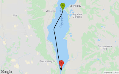
Middle of the night relocation of 5 miles

I am still banging my head against the bulkhead for allowing myself to anchor where we did.  Poor decision, should have anchored back up river at a spot which was tucked behind an island well away from the main channel.  Complacency is evil.  While I had talked to a tow captain via radio late in the day yesterday, and was assured we were in an ok spot, it still was not the best spot.  A tow and barge complex passed south to north at sunset and Serenity and crew were well clear, nearly 100 yards east of the channel so we felt OK with our anchor position.

Just after midnight,  how I heard the blaring blast of loud horns I don’t know but I did, and bolted up to the helm station.  The cockpit and helm station were flooded with bright white lights of the on coming tow. I nearly soiled my pants.  I fired up the diesel with really no place to move.  Water was too shallow behind us and the multiple barges too long to go forward.  The strong searchlight from the tow was illuminating a red buoy and clearly the tow/barge was on the wrong side of the channel, squeezing our safety space.  There was also a strong 10-12 mph north wind causing the tow/barges to drift toward us as the tow captain realized his error and had stopped forward movement and was beginning to back up.  At this time I was pretty sure the lead barge was going to hit us.  I stared in shock as the green navigation light at the starboard forward corner came dangerously close to Serenity.  How close?  Adrenaline, shock, disbelief, I probably estimated too close, but it was frighteningly too close.  With maneuver room, I went to the bow to retrieve the anchor while POC manned the helm.  Anchor up we maneuvered to the channel and the red buoy to our starboard bow—the same buoy the tow/barge was about to run over and got safely into the channel and in front of the stopped tow.  Back at the helm, I was finally able to contact the tow captain on the radio.  He also seems a bit confused and maybe in shock as we were.  I requested he shut off his brighter than the sun searchlight and Serenity would pass on the one whistle as we headed south and out of his way.  He complied and we passed safely port to port.

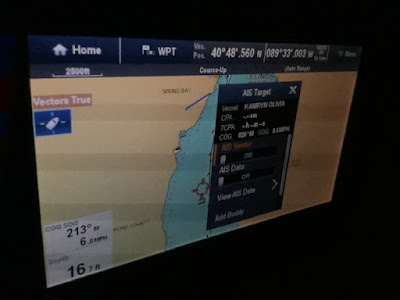
Late night AIS screen capture of tow/barge

Thank God for our safety, a full moon, clear skies, GPS and accurate electronic navigation charts enabling us to maneuver.  There were two marinas about five miles ahead but due to the lower river level, entry at night with uncertain visual guidance was not desired.  Studying the charts we found a spot where there was more water depth east of the channel and where the channel makes a gentle curved to the west.  Proceeding very slowly, and observing the unlighted day channel markers and visually sighting the lighted markers we pick our way south to where we felt we could get out of the channel, anchor and wait for sunrise.  We noticed the bright lights of a southbound tow/barge complex and confirmed via AIS it was traveling toward us.  I contacted the tow captain on Channel 13 and told him where we were and what we intended to do.  He acknowledged seeing us electronically and would find us visually once he got closer.  So we idled around in circles in 8 feet of water, in the dark, aided by GPS and electronic charts all the while watching the oncoming tow approach us.  This tow/barge complex passed easily 1/2 mile west of us.  Good to go we dropped the anchor at 0130.  Nearly two hours of maneuvering in the dark.  We hugged each other, calmed down, set the anchor alarm. Dazed and fatigued, surprisingly we fell quickly to sleep.

Around sunrise we woke up, still anchored in our safe spot and surveyed our surroundings.  Pretty close to the eastern edge of the river, but a good 1.5 miles from the western edge.  Channel markers well away from us.  Around 0800 I called the Illinois Valley Yacht Club on the phone.  Yes they had diesel but there was a leak but expected repairs after the weekend and yes they would take transit boaters and we were welcomed.  After last night we needed a break off the water and Serenity was at 1/3 fuel remaining and next available refuel was too far down the river.  Reviewing the checklists, hauled up the anchor, underway at 0840 and we safely secured in a marina slip at 0900.  We were greeted by the assistant harbor host and a neighboring boater who caught our lines.  Illinois Vally Yacht Club. What a welcoming place to relax.  Excellent bath and shower facilities, air conditioned spaces to cool off and a large swimming pool.  

We will remain here and wait for the diesel fuel delivery to be repaired.  We are visiting friends today.  We have boat projects and personal finance business to work on tomorrow.  Slow down a bit and study the charts.  

Lessons re-learned.  Complacency kills.  We finished the big waters, waves, winds of the Great Lakes to the calm and narrow waters of the inland waterways, so we relaxed our guard a bit.  While I had checked the river level, just had not paid much attention till last night.  The river is two feel below pool and we had less water to anchor in and less maneuver room last night.  Implied schedules with water travel lead to poor decisions.  Tow/barge complexes have the right of way because they don’t stop very fast and are restricted in their maneuver ability.  Humans make mistakes.  Last night’s tow captain clearly navigated outside of the channel; while we were clear of the channel, there really was no margin for errors.  Will not intentionally do that again.


5839 SM traveled; 2020.0 hours hobbs

Saturday, August 21, 2021

21 August, 2021. Long day down the Illinois River


68 SM; 9.2 hours, one lock

Last night might have been the most peaceful anchorage in a very long time.  Boat never rocked after sunset.  Peaceful morning.  No rush, goal only to go down the river safely.  We checked central Illinois weather; cloudy, hot with chance of showers and thunderstorms.  Good to go. Fired up the diesel and hoisted the anchor at 0750.  Smooth waters as we headed about 2 miles to our first lock.  Surprisingly, the lock master let us lock ahead of a tow/barge complete that was an hour away.  I figured we would have to wait.  Very friendly lock master, who came over to visit as we were securing.  Easy lock down of 14 feet then we were on our way.

Looking aft while secured in Starved Rock lock

Gates opening exit soon

 Starved Rock State Park forms the eastern boundary of the Illinois river.

Cliffs of the state park

Continuing down the river, much to my surprise the current not as strong because the dredged portion of the  waterway  floods a lot of the river valley results in decreased overall current. Only doing about 7.5-7.6 mph over the ground.  Lots of pleasure boats out today along with many tows pushing large barge complexes.  Only a couple of pinch points where we slowed allowing the commercial traffic the right of way.  Starting to see more homes along the waterway, mixed in with the commercial areas.  

Not sure what is going on here

Frequent sight along the waterway

Common sight; barges waiting for the tows

Decent anchorages are few today as we passed up a couple in order to travel another couple of hours down river.  We have anchored north of a point, about 50 yards off of the channel in shallow water.  We checked with a passing tow if this spot would be ok and keep us clear of traffic.  Tow Captain confirmed and would relay our position to the next  up bound tow.  So we called it a day and dropped the anchor at 1710 in 7 feet of water with the stern drifting into about 3.5 feet.  (Map). Winds forecast along with the slight current will keep us well clear.  Kim’s anchor video. Swim call again.  Water warm and I guess clean enough.  Saw plenty of folks today swimming.   After a mostly cloudy and drizzly day with thunderstorms remaining distant, it has cleared off nicely.  Beautiful sunset.  Fully moon will probably wash out the stars tonight.  If we can stay awake long enough to look.

Passing tow/barges near Serenity


5830 SM journeyed; 2017.5 hours hobbs.


20 August, 2021. Easy day dodging tows and barges.


47 SM; 6.7 hours and three locks

Safe night last night on the Joliet wall.  Having the police outpost a few yards away probably did not hurt. Good sleep, but a large tow/barge complex passed and rocked the boat but not too bad and our large round ball fenders kept Serenity clear of the concrete wall.  Hot, hazy and humid forecast for the day ahead.  Coffee, bible study, route study and a quick phone call to the next lock two miles away checking on status; all a go.  Checklists complete we untied the lines and pushed off the wall at 0715.  We are cruising down hill all the way to the Ohio river.  Current has been marginal up until today.  Today onward the current will build up to 1-1.5 MPH on the Illinois waterway.  Great, faster without burning more diesel.  

Scenery less industrial, though there are pockets of heavy industry with gravel/sand pits and grail silos with tows and barges working the river and river banks, but becoming more rural and evidence that we have entered corn country.  Up first is Brandon road lock and dam.  First time we have locked with a tow/barge in the lock.  No waiting this time.  34 foot descent. 

Approaching the lock

Great signage on these USACE locks

Current has increased to about one MPH and will sustain the remainder of the day.  Speed over ground (SOG) up to 8.2 mph.  Two more locks to negotiate today. Dresden Lock and Dam with a 20 foot descent and Marseilles Lock with a 26 foot descent.  Both locks were shared with tow/barge combinations.  Easy in and out and minimal waiting.

Floating bollard; rises/falls with the lock water level. Loop a line around

Lock doors opening

Exiting lock

Smooth non-confrontational day along the water.  Commercial traffic moving up and down the river but no real tight pinch points today.  Massive grain silos along both sides of the waterway.  Saw three Eagles today.  First sighting in a very long time.  Many more wading birds; great egrets and great blue herons.  Ubiquitous ducks and geese along the shore or in the water.

Tow building barge packages

Power plant cooling tower ahead making a cloud

One of many grain silos 

Exiting today’s last lock we proceeded three miles to an anchorage just north of Ottawa, IL.  Bull’s Island seems to be what remains of an oxbow along the river, separate and well clear of the river channel.  We exited the river with caution at slow speed and watching the depth sounder, easy clearance with 10 feet of water under the keel.  We dropped the anchor at 1510 and secured the great Yanmar diesel.  (Map). The southern end of this bow is reported shoaled and only shallow draft boats pass.  So, we are well clear of the tow/barge traffic that travels 24/7.  Kim’s anchor video.  Water temp is 84 and air is 89.  Swim call!  We splash the dinghy and lower the boarding ladder from the swim platform.  There are a few water skiing boats and folks enjoying the smooth waters.  Several jet skies but not obnoxious.  Folks enjoying the water.  We have not used our pool noodles in a long time—out they came.  Refreshing water, not as crystal clear as the Great Lakes, but at least 20 degrees warmer.  So if the locals swim and ski in it, well, I went swimming in it too.  Swimming off and on until sunset. Final swim with a bar of soap in hand.  

Big full moon rising over the anchorage

5762 SM traveled; 2008.3 hours hobbs


Thursday, August 19, 2021

19 August, 2021. Goodbye Great Lakes; hello inland waterways


42 SM; 7.4 hours and two locks

Leisurely morning as I had talked to the Chicago lock tender last night and he said arrival around 0930 would keep us clear of all the commercial tourist traffic.  So after coffee and only briefly looking at Chicago weather we took a good three mile walk.  Returning, we had breakfast, filled the water tank and prepared lines and fenders for today’s locks.  Ready to go as the morning was warming up fast we untied the lines and eased out of our slip at 0850.  No-wake zone travel of about 1.5 miles and we arrived at the lock holding area and called the Chicago lock on channel 14.  Maintenance delay.  So we idled around for about 30 minutes.  

Approaching the Chicago Lock

Cleared to enter lock, we grabbed the lines and locked down three feet to the Chicago River level and exited the lock.  Pretty impressive traveling through downtown Chicago.  Each bridge has excellent signage so we were able to keep track of our process.  

Heading into the Chicago river canyon

Clearing SW of the city, both sides of the river became more and more industrial.  We had a 30 minute delay at an AMTRAC bridge due to train traffic.  Only bridge we could not clear today.  Probably almost an hour of engine time today was idling waiting on a lock or a bridge.  

There was a section about 15 miles long that was very industrial with heavy barge and tow traffic.  Rock and sand barges lined one side or the other.  We pulled off behind warped barges while a tow and barges passed.  No room for Serenity and the tow/barge combination.  He would have squished us like a bug.  We have to give way three times today.  

Waiting between barges as a tow/barge combination passes

Passed through the invasive fish electrical barrier with our shock, tingling or funny electronic abnormalities.  Barrier is attempting to stop the spread of Asian carp to the Great Lakes.  Barrier

Is this going to hurt?

Checking ahead, AIS did not indicate any commercial traffic at the  Lockport Lock and dam.  Radio contact with lock master;  he reported he would have the lock ready in a few minutes.  Shortly we entered and grabbed a floating bollard, tossing a line around.  Soon, we were ridding down 40 feet.  

Bottom of 40 foot drop; doors cracking open

Exiting Lockport Lock

Twenty minutes later we exited the lock and continued about six more miles to the free wall at Joliet, IL.  We swung Serenity around into the river current and secured our lines and the diesel at 1615. (Map)  This free wall had a bad reputation in years past, but it has been relocated a few hundred yards and is now beside a satellite police station.  We should be good to go.  Of note, we have left the cold water of the Great Lakes and the below normal temperatures of a few days ago.  Today at the free wall the water temp was 84 degrees with the air temperature 87.  But we have shade cooling Serenity and we are cooling in our cheap lawn chairs on the free wall. kim’s video

Completely different cruising today.  I never once checked the wave forecast; winds every hour or where a bail out point might be.  Quick look at Chicago weather this morning and we were good to go.  We did drive through the edges of a sizable thunderstorm cell with decent rain for about an hour.  No wind, just ripples on the narrow waterway.  Nice and comfortable.

Left overs and salad for supper on the Joliet free wall tonight.  So far, shade, nice breeze and pretty quiet.

5715 SM traveled; 2001.6 hours hobbs